Google Earth Engine Image Pre-processing : Background and methods Part I
Published on Apr 19, 2020 | Bikesh Bade | 3684 Views
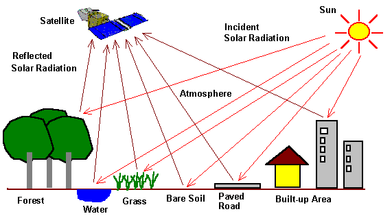
Google Earth Engine (GEE)'s public data archive includes more than forty years of historical imagery and scientific datasets, updated and expanded daily. The data catalog includes a variety of standard Earth science raster datasets. One can import these datasets into a scripting environment with a single click. When using remote sensing data several pre-processing steps can be applied that aim at removing artifacts from the images that are not related to the actual reflectance of the land cover such as sensor effects, atmospheric, and illumination conditions. However, the required preprocessing steps applied to the images also depend heavily on the intended use of the data.
1. When performing a sample-based classification of individual scenes or a temporal stack of scenes within a footprint, several pre-processing steps may be skipped because training and classification are performed within the same domain.
2. Whereas a rigorous pre-processing is required for trend detection algorithms, classifications across several footprints, or the classification of composite images.
In GEE, to get image composition there need to process different mathematical algorithm. Image composition refers to an approach that creates a single, cloud-free image composite by selecting for each pixel location the best pixel from a time-series of multiple images. The sequential workflow of potential pre-processing steps as follows:
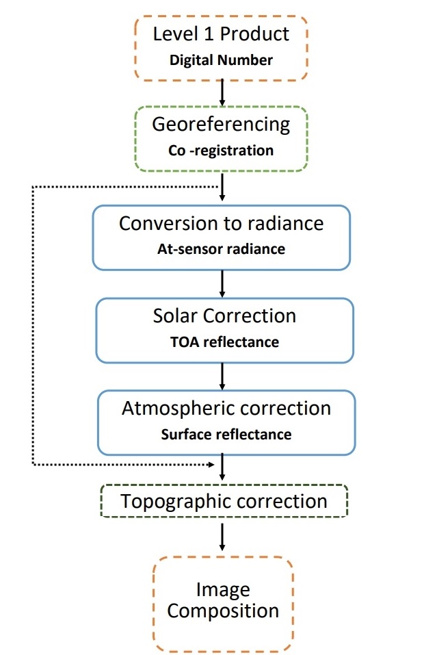
- Conversion to radiance: Conversion to radiance is the preprocessing step whereby the DNs are converted back to radiance (at-sensor radiance) by using recalling factor associated with each band for a given factor.
- Solar correction: accounts for solar influences on pixel values. Solar correction converts at-sensor radiance to top-of-atmosphere (TOA) reflectance by incorporating exoatmospheric solar irradiation (power of the sun), Earth-Sun distance, and solar elevation angle.
- Atmospheric correction: the energy captured by Landsat sensors is influenced by the Earth's atmosphere. These effects include scattering and absorption due to the interaction of electromagnetic radiation with atmospheric particles. Atmospheric correction attempts to account for these effects.
The remote sensing data provided as level 1 product and the band values being digital numbers (DN), first needs to be georeferenced and/or co-registered so that pixel location from one image to the other correspond (geometric correction). Next, several steps for an absolute correction are required so that we obtain the surface reflectance, which already allows comparison across images. These steps include conversion to radiance to obtain at-sensor radiance, a solar correction that results in the top of atmosphere (TOA) reflectance, and the atmospheric correction that provides surface reflectance (SR). Which finally leads you to the Image composition after topographical correction.
Responses

Elton
concise, thank.
- Apr 23, 2020 |


