ESRI 10m Land Cover 2020 in GEE
Published on Jul 19, 2021 | Bikesh Bade | 3966 Views
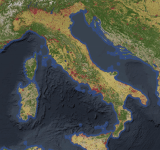
ESRI 10-meter resolution map of Earth’s land surface from 2020 with High-resolution, open, accurate, comparable, and timely land cover maps in GEE.
In this example, we know how to load ESRI land use data for the desired location.
// world boundary data
var worldcountries = ee.FeatureCollection('USDOS/LSIB_SIMPLE/2017');
var filterCountry = ee.Filter.eq('country_na', 'Italy');
var italy = worldcountries.filter(filterCountry);

// clip function
function clip(Image){
  return Image.clip(italy)
}

// Esri Landuse landcover 10m data
var esri_lulc10 = ee.ImageCollection("projects/sat-io/open-datasets/landcover/ESRI_Global-LULC_10m").map(clip)


// Define a dictionary which will be used to make visualize image on map
var dict = {
  "names": [
    "Water",
    "Trees",
    "Grass",
    "Flooded Vegetation",
    "Crops",
    "Scrub/Shrub",
    "Built Area",
    "Bare Ground",
    "Snow/Ice",
    "Clouds"
  ],
  "colors": [
    "#1A5BAB",
    "#358221",
    "#A7D282",
    "#87D19E",
    "#FFDB5C",
    "#EECFA8",
    "#ED022A",
    "#EDE9E4",
    "#F2FAFF",
    "#C8C8C8"
  ]};

// Add image to the map
Map.addLayer(italy, {}, 'USDOS/LSIB/2017');
Map.addLayer(esri_lulc10.mosaic(), {min:1, max:10, palette:dict['colors']}, 'ESRI LULC 10m')
Get the code in the link
Link to ESRI land use link


